The Big Sur backcountry offers a bounty of hiking trails and wilderness backpacking
The Ventana Wilderness owes its name to a dramatic mountain peak known as Ventana Double Cone. Legends relate that at one time the unique notch at the mountain’s top was roofed over by a rock bridge. Because of this legend, the early Spanish inhabitants named the outcrop “Ventana,” which means window in Spanish. The Ventana Wilderness contains 240,026 acres straddling the Santa Lucia Mountains south of the Monterey Peninsula and is part of the Los Padres National Forest. Los Padres National Forest encompasses nearly two million acres in the beautiful coastal mountains of central California. The forest stretches across almost 220 miles from the Big Sur coast in Monterey County to the western edge of Los Angeles County.
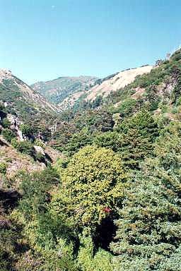
Topography in the Wilderness is characterized by steep-sided, sharp-crested ridges separating V-shaped valleys. Elevations range from 600 feet, where the Big Sur River leaves the wilderness, to about 5,750 feet at the wilderness boundary circumventing Junipero Serra Peak. Most streams fall rapidly through narrow vertical-walled canyons flowing on bedrock or a veneer of boulders. Waterfalls, deep pools and thermal springs are found along major streams.
The climate is mild. Precipitation falls primarily as rain from November to April and ranges widely from more than 100 inches annually along the Coast Ridge to less than 30 inches only a few miles inland. The cool marine influence does not extend past the coastal ridges, thus most areas east of the divide are hot and dry during the Summer and early Fall.
Much of the Wilderness is covered by chaparral. Contrasting annual grass meadows and open pine stands may be found throughout the Wilderness. The deep canyons cut by the Big Sur and Little Sur Rivers support virgin stands of coastal redwoods. Scattered stands of the endemic Santa Lucia Fir are found in rocky outcrops and rugged slopes at higher elevations. This rare spire-like tree is only found in the Santa Lucia Mountains.
Los Padres National Forest
Contact Information & FAQ's
Los Padres National Forest or
call 831.385-5434
Los Padres National Forest maps, publications, alerts & notices, learning center, "about the forest," news and events.
FREQUENTLY ASKED QUESTIONS
1) Do I need a backcountry permit? No
2) Do I need a Campfire Permit? Yes, and you can download it here.
3) Do I need a campfire permit if I'm using a gas stove? YES
4) Is Plaskett Ridge open for camping. No. See Forest Order 5) CAMPFIRES ARE ALLOWED IN BACKCOUNTRY AS OF 12/20/23
Hikers and backpackers can find solitude while enjoying the diverse natural features of the Santa Lucia Mountains. The 237 miles of trails provide access to the 55 designated trail camps.
The Pine Ridge Trail (closed until further notice) provides visitors to the Big Sur Valley with one of the most popular portals into the Ventana Wilderness. The recently opened trailhead at the Big Sur Station has excellent parking, plenty of water, and clean restrooms. The Nature Station Store, which is located at the Big Sur Station, provides hikers with maps and other literature associated with the natural history of the Big Sur region.
When hiking the trail please refrain from entering the campground section of the park. Try to keep your impact to a minimum. Pack out your trash and protect natural water sources. Water should always be boiled or filtered before drinking.
Looking for a local tour guide to maximize your time in Big Sur? Visit our Big Sur Hiking, Tours, and Activities page to find local, knowledgeable (hiking) guides who can help you explore the beauty and wonder of the Big Sur region.
For further information regarding current conditions and safety tips, please contact your nearest Forest Service office. A list of designated Campfire Use Sites is available on the Los Padres National Forest website at http://www.fs.usda.gov/lpnf or by contacting the Forest Service district office nearest you.
WILDERNESS HIKING ASSETS: Ventana and Silver Peak wilderness maps can be found at http://bigsurtrailmap.net/ with very useful illustrations of camps, water sources and points of interest.
Ventana Wilderness Alliance maintains an online trail guide offering current trail conditions to Sykes Hot Springs as well as many other trails in the Ventana Wilderness, Silver Peak Wilderness, and Los Padres National Forest. It is a very valuable asset in educating yourself about the Big Sur backcountry.
Hike Los Padres, A Free Resource for Exploring. This website was created with the mission of being a source of shared information on trails, camps and locations across the entire Northern and Southern portions of the Los Padres National Forest.
Before hiking into the Ventana Wilderness area you'll need to pick up a free campfire permit or you can fill it out online and keep it with you. Wilderness permits are not needed.

 The Ventana Wilderness contains 240,026 acres straddling the Santa Lucia Mountains south of the Monterey Peninsula and is part of the Los Padres National Forest. Los Padres National Forest encompasses nearly two million acres in the beautiful coastal mountains of central California. The forest stretches across almost 220 miles from the Big Sur coast in Monterey County to the western edge of Los Angeles County.