Big Sur Public Restroom Locations
Public Restroom Locations in Big Sur
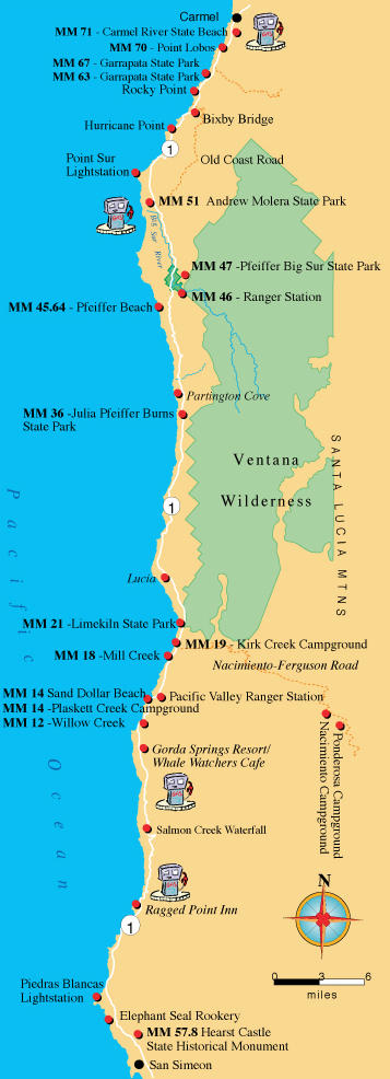
Restrooms located in State Parks and at these campgrounds allow free access to the restrooms with a limited time to use the facilities. We've added the gas station locations as a public service because of the limited gas available in Big Sur.
 Monterey County
MM 71 Carmel River State Beach
MM 70 Point Lobos State Natural Preserve
MM 67 Garrapata State Park - North
MM 63 Garrapata State Park - South
MM 51 Andrew Molera State Park
MM 47 Pfeiffer Big Sur State Park
MM 45.64 Pfeiffer Beach -Sycamore Canyon Rd + 2 miles west of Highway 1.
MM 46 Big Sur Station Visitor Center
MM 36 Julia Pfeiffer Burns State Park
MM 21 Limekiln State Park
MM 19 Kirk Creek Campground
MM 19 Nacimiento Campground Nacimiento-Fergusson Rd + 11 miles east up N-F road. See map.
MM 18 Mill Creek Picnic Area & Beach
MM 14 Sand Dollar Beach
MM 14 Plaskett Creek Campground
MM 12 Willow Creek Picnic Area & Beach
San Luis Obispo County
MM 57.8 Hearst Castle Historical Monument Vicinity
Mile markers run from south to north from county lines. So, Carmel River State Beach is 71 miles north of the Monterey County Line. Hearst Castle is located 57.8 miles north of the southern border of San Luis Obispo County line.